AI Urban Design Generator – Supercharge Urban Planning & Design with AI Renders
Design, simulate, and visualize cities with ArchiVinci’s AI-powered urban planning tools—purpose-built for architects, planners, and municipalities.

Masterplan AI
Masterplan
Quickly add colors, textures, and material styles to your site plans.
UNLIMITED with premium plans

Transformation From Draft to Photorealistic Design
From Blueprint to Reality
.webp)
Turn architectural sketches into lifelike renders! See your designs transformed from simple lines into vibrant urban visuals.
Site Plans Come Alive
.webp)
From plain outlines to colorful living spaces… AI brings site plans to life with stunning, realistic details.
Concept to Realistic Render
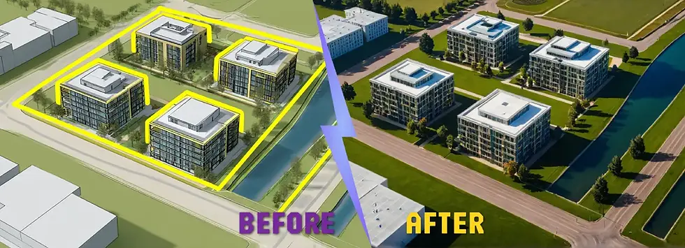.webp)
Transform basic massing models into photorealistic office complexes. Make your project presentations truly impactful.
What Is an AI Urban Design Generator?
AI Urban Design Generators are the tools that uses artificial intelligence to create urban planning concepts and architectural visualizations based on user-defined inputs and parameters. These architectural tools assist in the planning and development of urban environments by analyzing spatial data to propose city layouts, street networks, and zoning solutions.
The Evolution of Urban Planning Through Artificial Intelligence
From hand-drawn plans to GIS tools and now AI-driven engines, urban design has seen a technological shift. AI introduces predictive, generative, and simulation capabilities to traditional workflows.
Differences From Traditional City Planning Methods
Traditional methods rely on manual calculations, zoning codes, and iterations, while AI enhances accuracy, speeds up processes, and offers data-backed design alternatives.
Role of GIS, CAD, Satellite Imagery, and Machine Learning in Urban Design
AI Urban Design combines inputs from GIS layers, CAD files, satellite data, and aerial imagery. Machine learning models process this data to identify patterns, optimize land use, and generate future-ready urban layouts.
Key Benefits Of Using AI In Urban Planning
-
Significantly reduces time spent on iterations
-
Produces data-driven and evidence-based design outcomes
-
Improves accuracy in zoning and massing
-
Enhances community engagement through visual outputs
-
Supports resilience and sustainability goals
The Role of AI in Modern Urban Planning
Scenario-Based Masterplanning for Future-Proof Development
AI tools can simulate various development scenarios under different assumptions—helping planners prepare for growth, transportation shifts, or climate impacts.
Integration of Sustainability Metrics and Climate-Responsive Design
AI can incorporate data on sun paths, wind flow, stormwater management, and carbon emissions to shape eco-conscious urban solutions.
Public Engagement Through Visual and Participatory Tools
AI-generated visuals and models can be shared with communities, encouraging feedback and transparent participation in design decisions.
How ArchiVinci’s AI Urban Design Generator Works
Step 1: Export or Screenshot Your Site Plan
Start by exporting your urban site plan as a clean PNG or JPEG file—or simply take a high-resolution screenshot of your digital plan. This image serves as the foundation for your masterplan coloring.
Step 2: Upload to the Masterplan AI Module
Drag and drop your image into the ArchiVinci Masterplan Generator. The system recognizes the layout, blocks, roads, and landscape elements through visual analysis.
Step 3: Add Optional Prompts for Style or Season
Want a watercolor look, a snowy winter setting, or fall foliage? Add these preferences in your prompt. You can guide the AI to reflect specific moods, seasons, or artistic styles.
Step 4: Color and Download
Within seconds, ArchiVinci transforms your black-and-white site plan into a vibrant, fully-colored masterplan. Enhance and download your result in high resolution with the AI Render Enhancer, perfect for presentations, reports, or iterative design reviews.
How AI Urban Design Enhances City-Making Processes
-
Allows planners to iterate faster and smarter
-
Uses algorithms to balance density and building heights efficiently
-
Includes simulations for sun exposure, wind corridors, and pedestrian flow
What Makes ArchiVinci’s AI Urban Design Tool Purpose-Built for Planners
-
Specializes in zoning logic, setbacks, FAR, and other regulatory layers
-
Compatible with common GIS, CAD, and BIM tools
-
Offers flexible outputs for urban designers, public agencies, and real estate developers
Technical Capabilities Behind ArchiVinci’s AI Urban Design Generator
-
Spatial parsing from GIS, drone, or satellite inputs
-
Procedural generation of zoning and circulation systems
-
Environmental simulation tools (wind, shade, heat)
-
Diffusion models for photorealistic urban renders
Urban Planning Focus Areas That Benefit Most from AI
Land Use Planning
AI helps planners distribute functions like housing, retail, and green space more efficiently across a site or district. This leads to more balanced and accessible communities with better walkability, reduced congestion, and minimized land waste.
Street Network Design
AI-generated layouts improve traffic flow and walkability by creating well-connected street grids and road hierarchies. It ensures logical transitions between different zones and encourages pedestrian-friendly environments while maintaining vehicular efficiency.
Green & Open Space Integration
AI makes it easier to balance density with accessible parks, plazas, and green corridors—essential for livability. It identifies optimal green locations that enhance both ecological quality and user well-being in dense urban settings.
Building Density & Massing
With AI, planners can explore building arrangements that align with height limits, views, and site coverage goals. It helps optimize land usage and architectural composition in accordance with zoning codes or design vision.
Context and Environmental Fit
AI accounts for terrain, sun paths, wind flow, and climate zones—leading to smarter, site-sensitive designs. The resulting layouts are more comfortable, energy-efficient, and better adapted to natural conditions.
Social Interaction and Public Realm
AI supports the creation of plazas, gathering spaces, and pedestrian nodes that strengthen community life. These spaces encourage social engagement, promote walkability, and contribute to safer, more vibrant neighborhoods.
Zoning and Regulation Support
When integrated, AI can follow local rules around land use, building heights, setbacks, and access requirements. This reduces regulatory risks and streamlines approval processes with urban planning authorities.
Sustainability and Resilience
AI helps apply green strategies like permeable surfaces, shade coverage, passive cooling, and stormwater management. These considerations are integrated at the concept stage to promote resilience and long-term environmental benefits.
Real-World Applications of AI in Urban Design Tools
-
Municipal and smart city planning
-
Sustainable infrastructure strategy
-
Real estate and large-scale developments
-
Urban design research and student projects
ArchiVinci’s AI Urban Design Modules
-
Masterplan AI – Transform site plans into vibrant garden landscapes
-
Landscape AI – Capture your garden, redesign with AI-powered landscaping
AI Urban Design Generator vs. Traditional Masterplanning
-
Time and Cost Advantages – Faster turnarounds and lower labor costs
-
Precision and Design Fidelity – Rule-based spatial layouts that align with local policies
-
High-Quality Visual Outputs – Export-ready renders and masterplans
-
Speed of Iteration – Easily generate and compare alternatives
-
Client-Ready Visuals – Better presentation tools for stakeholders
Best Practices for Achieving Optimal Results with AI Urban Design
-
Start with clean GIS/CAD inputs for precision
-
Calibrate zoning rules and density constraints
-
Run multiple scenarios for comparison
-
Use visualization layers for stakeholder presentations
For more visualization and rendering options beyond urban design, explore our complete suite of AI architectural rendering tools.
FAQs - Common Questions About AI Masterplanning
Can AI Design Entire Cities Or Only Districts?
AI can design both, but performance depends on input scale and detail. Districts are more commonly tackled for higher accuracy, though city-scale conceptual studies are possible.
Can AI Generate Both 2D Site Plans And 3D Urban Renders?
Yes. Most tools start with 2D zoning or layout plans, and some can upscale to 3D renders or visualizations, especially if linked with platforms like ArchiVinci.
What Types Of Input Provide The Most Accurate Results?
Clean site plans (in PNG, JPEG format), architectural renders, or well-structured diagrams work best. Overlays or annotations can confuse AI segmentation.
Can Users Customize Architectural Styles Or Street Layout Logic?
Yes. Prompts can include specific requests like "Mediterranean village," "mid-rise residential blocks," or "grid-based streets" to influence results.
Is It Possible To Adjust Land Use Mixes Or Building Heights In Real Time?
While some tools allow general prompts (e.g., “add more commercial”), detailed real-time control over land use and height typically requires manual input or CAD integration.
How Does AI Interpret GIS And Satellite Data?
AI reads patterns in satellite imagery, elevation maps, or GIS overlays (roads, land use, etc.) to inform spatial logic. This often powers density or zoning suggestions.
Does The AI Urban Design Tool Recognize Terrain And Topographic Constraints?
Some advanced models factor terrain, especially if elevation or slope data is embedded in the input. ArchiVinci focuses primarily on plan-level visual logic.
Is The AI Capable Of Generating Context-Aware Urban Interventions?
Yes. When site inputs include neighboring elements (parks, buildings, roads), AI aligns interventions like new blocks or paths to those existing conditions.
How Does AI Balance Green Spaces And Built Environments?
Using zoning algorithms and segmentation, AI allocates green space based on density, proximity to edges, and spacing between zones.
Can AI Simulate Mobility, Sun, Wind, And Climate?
Some urban design tools simulate environmental flows; however, ArchiVinci’s focus is more visual than simulation-based. These insights are planned for future integration.
Can AI Urban Design Tools Optimize Density And Land Use Automatically?
Yes. The AI can calculate plot ratios, distribute functions across sites, and propose layouts that meet target density goals.
Does It Support Local Planning Regulations And Zoning Codes?
Currently, prompts can simulate general zoning patterns (residential, mixed-use), but strict legal compliance with municipal codes must be reviewed manually.
Does AI Help With Participatory And Sustainable Urban Planning?
Yes. Fast, visual outputs make it easier to gather community feedback and apply green planning strategies in the early concept phase.
Can AI Tools Be Used For Rapid Prototyping In Public Design Workshops?
Absolutely. They allow real-time ideation with stakeholders, instantly generating visual options for discussion.
How Does AI Improve Masterplan Visualization And Communication?
The outputs are more vibrant, readable, and conceptually resolved, which helps convey design thinking to non-experts.
Is It Possible To Export Designs Into CAD, GIS, Or BIM Platforms?
Currently, exports are in raster image format (JPG, PNG). Vector and CAD outputs are on the roadmap for future versions.
Can ArchiVinci’s Tools Be Used In Competitions Or Academic Research?
Yes. The tools are widely used for architecture school projects, urban design competitions, and research studies needing fast visual iterations.
How Fast Is AI Compared To Traditional Masterplanning Workflows?
What may take a team days can be done in minutes—especially helpful in competitions, early concepts, or feasibility studies.